This innovative tool aims to improve the way we monitor and manage pesticide risks, supporting the transition to more sustainable agricultural methods.
The EU pesticide risk assessment process evaluates the potential risks of exposure to residents. The assessment rejects pesticides that cause unacceptably high exposure levels or suggests ways to reduce the level of contact to acceptable levels. National authorities, however, can promote sustainable agriculture by further reducing exposure, focusing on areas with higher exposure levels.
The JRC study complements the pesticide risk assessment by analysing the spatial distribution of potential risks posed by non-dietary exposure, in particular due to living near agricultural land where pesticides are applied to crops.
The prototype indicator combines, for the first time, detailed pesticide sales data, crop distribution, and population distribution maps to identify regional hotspots where potential exposure levels are higher due to living near an agricultural activity. The indicator takes into account factors such as the type and amount of pesticides used, as well as proximity to agricultural fields. Integrating these different datasets offers spatially resolved indications of pesticide exposure that is not possible to achieve using current indicators.
Pilot study investigating potential pesticide exposure in France
The JRC conducted a pilot study using publicly available data from France. These data are unique in that they provide a reliable record of pesticide sales and crop distributions at the postcode level. Most other data sources relate to aggregations over much larger geographical areas.
JRC scientists looked at a set of 388 pesticides that are used in plant protection products in France. The aim was to show the potential total pesticide load – the amount of chemical used, multiplied by how toxic it is - at the ‘parcel’ level, covering 9.5 million parcels of land.
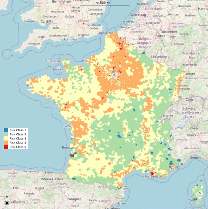
Pesticide exposure was calculated according to the EU guidance that estimates exposure of residents and is used officially in the pesticide risk assessment process. However, due to lack of data about when the pesticides were used, the study assumed that all pesticides used per year are applied at the same moment. In addition, measures typically taken by farmers to reduce exposure from spraying were not taken into account.
Although this approach only approximates exposure in more of a worst-case scenario, it does provide a useful means to compare localised areas with potentially lower and higher annual exposure levels. Further research should focus on implementing data on actual use in time and space and the application of risk mitigation measures as soon as this becomes available.
Specific crops lead to higher pesticide exposure
The results of this research also showed that pesticide treatment of certain crops, such as grapevines, spring barley, potatoes and sugar beets, are more likely to contribute to human contact with pesticides. Other factors include people physically entering treated fields and the use of pesticides that more easily produce vapours when pesticides evaporate into the air making them easier to inhale.
However, exposure through the skin and as a result of spray drift during the application were found to have less of a contribution.
If developed further, this novel indicator could support EU efforts to advance sustainable agricultural practices by providing a more nuanced understanding of potential pesticide exposure.
Related content
Details
- Publication date
- 27 May 2025
- Author
- Joint Research Centre
- JRC portfolios 2025-27